Search Results
110 items found for ""
- How to Defend Against Interference at Sea
How to Defend Against Interference at Sea DOWNLOAD PDF By Chris Kiedrowicz DOWNLOAD PDF
- BroadSim Wavefront | Phase-Aligned CRPA Testing
Home • Products • GNSS Testing & Simulation • BroadSim Wavefront BroadSim Wavefront Software-Defined CRPA Test System BroadSim Wavefront PRODUCT | GNSS TESTING & SIMULATION Scalable 4-16 elements at 600+ signals per element Iteration Rate 1,000 Hz Phase-Coherent 1° 1σ Real-Time Automated phase calibration NAVWAR Built-in jamming and spoofing ANY QUESTIONS? GET QUOTE About Protecting your GNSS systems from jamming and spoofing is more critical now than ever before. BroadSim Wavefront was designed to enable easier and more affordable CRPA receiver testing, leveraging proven software-defined architecture. Applications – Test CRPA electronics/multi-element antennas Features – IQ generated in GPU not FPGA – PXE (pixie) system architecture - single computer operation – Unlimited number of in-band and out-of-band jamming signals with no additional hardware – Create dynamic transmitters and user-defined waveforms – Simultaneously simulate multiple threats including jamming, spoofing, and repeating – Single pane view of all system nodes and their signal simulations Why Develop a New Wavefront Simulator? – High-end PNT systems are using AJAS - very few Wavefront simulators exist – Wavefront simulators are expensive - standard configurations can cost millions – Jamming/spoofing is often not a part of the solution - the user must integrate additional hardware – Scenario creation is complicated and limited - requiring trained, expert PNT engineers The Status Quo Difficult calibration routine Physically large and not scalable Custom one-off solutions Limited or no API control Limited spoofing/repeating capabilities BroadSim Wavefront Scalable and affordable Commercially available Easy to use and calibrate Robust API: C++, C#, and Python Jamming, spoofing, and repeating RESOURCES On-Demand Webinar Button Watch The Next Generation of CRPA Testing Reimagined for the User and uncover the methods and solutions for testing CRPA. Technology Demonstration Button Watch Generating Threats with BroadSim Wavefront and see a unit under test tracking signals and their angles of arrival for yourself An Engineer's Guide To CRPA Testing Button Learn about applications and use cases for CRPAs, how they work and the methods for testing them, plus what solutions are available today. Click to download the BroadSim Wavefront data sheet. VIEW DATA SHEET
- Epsilon | Safran Federal Systems
Home • Products • Inertial Navigation Systems • Epsilon ™ Epsilon™ Land platform inertial navigation unit Epsilon ™ PRODUCT | INERTIAL NAVIGATION SYSTEMS Azimuth accuracy < 1° Size 4.3 x 4.3 x 3.3 in Technology resonator gyro Alignment Time 15 scd Reliability (MTBF) > 100,000 h ANY QUESTIONS? GET QUOTE About Versatile, Epsilon™ family provides advanced applications, even in GNSS denied environment: navigation (position & heading), aiming aid, driving aid. It covers all tactical applications from logistic to infantry fighting vehicles, as well as main battle tank. Can be integrated with small artillery caliber to provide precision pointing Connectable to any Battle Management system Immune to magnetic disturbances Autonomy and reliability in any circumstances Thanks to their advanced resonator gyros, Epsilon™ One and Epsilon™ 10 systems provide advanced navigation capabilities without being GNSS dependent. Epsilon family integration into vehicles is easier than legacy systems based on magnetic sensors. Tailored to your needs Versatile, Epsilon™ family integrates with all land platforms, from artillery to logistics. Its Epsilon™ One and Epsilon™ 10 units cover navigation, aiming and driving needs by guaranteeing optimal performance: Heading : < 0.85° H. Position: 1% DT Pitch & Roll: 0.3° Size: 1 L Click to download the Epsilon ™ data sheet. VIEW DATA SHEET
- Talen-X is now a part of Orolia!
Talen-X is now a part of Orolia! ROCHESTER, NY, September 18, 2019 Orolia Defense & Security has completed the acquisition of TalenX, a U.S. company specializing in advanced Global Navigation Simulation System (GNSS) solutions and Interference, Detection, and Mitigation (IDM) technologies. “Orolia Defense & Security is excited to bring on Talen-X as they offer a complementary portfolio of solutions and bring many years of advanced PNT experience to the team. We look forward to continuing their growth by providing additional resources and capabilities while ensuring the growth and success of their current customers” said Hironori Sasaki, President of Orolia Defense & Security. In early 2019, Orolia Defense & Security spun off as a separate entity from its parent company Orolia, with the mission of providing resilient Positioning, Navigation and Timing (PNT) solutions and custom engineering services to U.S. Government agencies, U.S. Defense organizations, and their contractors. Orolia Defense & Security operates as a proxy-regulated company, Free of Foreign Ownership, Control, or Influence (FOCI). As such, Orolia Defense & Security is approved to work on the full spectrum of U.S. Government classified and unclassified projects and is positioned to support strategic partnerships in the development of key PNT technologies for the defense market. “Our culture of innovation, together with our demonstrated testing capabilities, will complement Orolia’s technology expertise and significantly enhance the reliability, performance and safety of military operations,” said Tim Erbes, Orolia Defense & Security’s Director of Engineering. The acquisition also enables Talen-X's existing resources, operations and capabilities to be scaled and accelerated to better support the warfighter. At Modern Day Marine and Association of the U.S. Army (AUSA), Orolia Defense & Security is showcasing its latest technologies such as the BroadSim Wavefront GNSS simulator, ThreatBlocker jamming/spoofing detection and protection device and BroadShield threat detection software. Authorized for use with U.S. military signals such as GPS L1/L2, P, Y, and M-Code, Orolia’s Simulation and IDM solutions serve the most unique and challenging program requirements. For more information about Orolia Defense & Security, visit their website at www.OroliaDS.com About Orolia Orolia is the world leader in Resilient PNT solutions that improve the reliability, performance and safety of customers’ critical, remote or high-risk operations. Resilient PNT is the convergence of positioning, navigation and timing technology with non-traditional and emerging technology to improve the reliability, performance and safety of mission-critical applications in the air, on land, in the sea, and in space. Resilient PNT solutions are used where even the smallest discrepancy in data accuracy, availability and stability can result in a mission failure, loss of life, battlefield disadvantages, and significant economic loss. www.Orolia.com Contact: Rachael Smith 614-736-3736 rachael.smith@oroliaDS.com VIEW PDF
- Skydel Wavefront Calibration Tech Brief
Skydel Wavefront Calibration Tech Brief DOWNLOAD PDF By Jaemin Powell DOWNLOAD PDF
- Controlling Power & Pseudorange Offsets of a Repeater Threat
Controlling Power & Pseudorange Offsets of a Repeater Threat DOWNLOAD PDF By Jaemin Powell DOWNLOAD PDF
- U.S. Army Selects Orolia Defense & Security as a Top-5 Winner in XTech Plugfest Competition
U.S. Army Selects Orolia Defense & Security as a Top-5 Winner in XTech Plugfest Competition ROCHESTER, NY, December 14, 2021 Prevails in Military’s Pursuit of Future CMOSS PNT Solutions Recognized for its outstanding technology achievements and the potential for impact to the United States Army and Department of Defense, Orolia Defense & Security, the leading U.S. Resilient Positioning, Navigation and Timing Mission Partner™, was selected by a panel of judges as a finalist during the 2021 xTech Plugfest competition. Hosted by PEO IEW&S, PM-PNT, the event, which allowed industry participants to demonstrate C5ISR/EW Modular Open Suite of Standards (CMOSS) capabilities via PNT cards, switch cards, and chassis, was held at the Open Innovation Laboratory (OIL) on Aberdeen Proving Grounds, Maryland November 8-19. CMOSS prescribes criteria for integrators that reduce the size, weight, and power (SWaP) of C5ISR and EW systems while increasing their flexibility and adaptability by enabling the sharing of hardware and software components. Orolia submitted a CMOSS timing card and was formally recognized as a top-5 winner at OIL’s open house (totaling 200+ attendees) for demonstrating their capabilities and commitment to supporting the US Army and DoD in pursuit of future CMOSS PNT solutions. “I am extremely proud of our team for their efforts and sharp-wittedness in developing and presenting this technology at an accelerated level,” said Conrad Meyer, director of business development at Orolia Defense & Security. “We are honored to have taken part in this event and to be distinguished among many contenders.” Orolia’s prototype has a plug and play architecture powered by its FlexFusion engine®, with additional capability for jamming and spoofing detection via its patented BroadShield software and is designed for easy in-field-upgradability. Orolia plans to release a commercially available, fully compliant CMOSS/SOSA PNT card product for use in military air and ground mounted systems in 2022. From essential timing & synchronization, to all-in-one PNT, Orolia Defense & Security offers modular solutions based on open standards, made to be secure and rugged, providing resiliency, high performance, and continuous operation in the field. Learn more at www.OroliaDS.com/resilient-pnt . About Orolia Defense & Security Orolia Defense & Security provides Resilient PNT solutions and custom engineering services to U.S. Government agencies, defense organizations and their contractors. Orolia Defense & Security is authorized to work on the full spectrum of U.S. Government classified and unclassified projects, in addition to supporting strategic partnerships for key defense PNT technologies. www.OroliaDS.com Orolia Defense & Security operates as a proxy-regulated company and wholly-owned subsidiary of Orolia. Contact: Rachael Smith 614-736-3736 rachael.smith@oroliaDS.com VIEW PDF
- Land Vehicle Navigation in GNSS-Denied Environments for Defense Applications
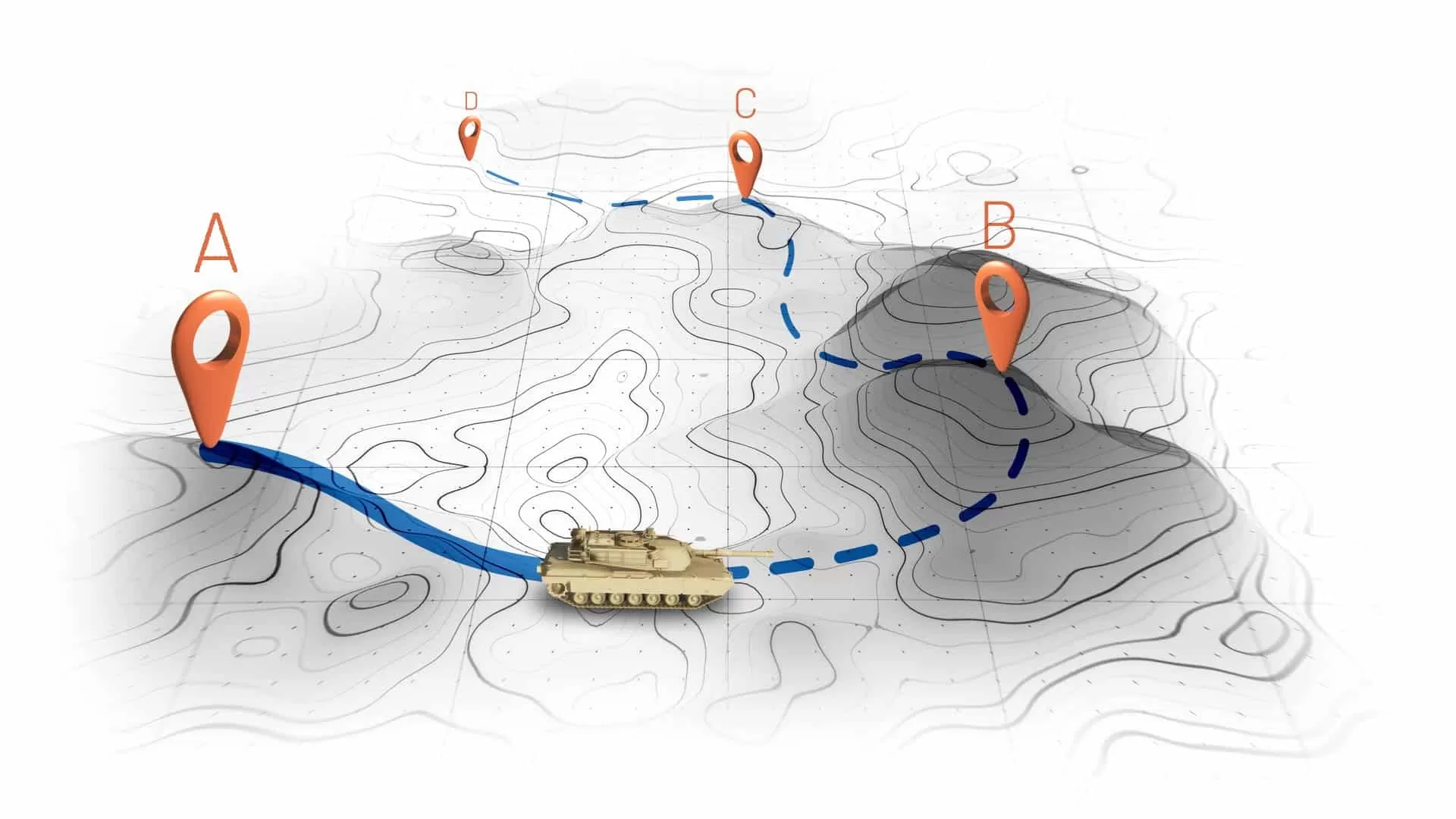
Land Vehicle Navigation in GNSS-Denied Environments for Defense Applications DOWNLOAD PDF By Anthony Full Problem We Solve In order to safely travel from one location to another during an operation, or maintain navigation capabilities in a contested environment, ground vehicle crews need ways to protect against GPS satellite signal threats and ensure that they reach their intended destination. Operating in a GNSS-denied environment presents challenges to most navigation systems, because they can either be jammed, or deceptively guided off course via spoofing attacks. An Inertial Navigation System (INS) that provides reliable position and heading data without the aid of GPS satellite signals is a unique backup solution because it allows vehicles to stay on course and maintain awareness of where they are as if they never lost connection with GPS. An INS can provide the critical current-location data and ensure that other navigation equipment continues to operate during the mission. Why Is It Important Precise location and navigation capabilities are essential for mission planning, execution and coordination with other units. Inaccurate navigation can lead to mission failure, unintended engagements, or even friendly fire incidents. Ground vehicles in defense operations often navigate in challenging environments where traditional GPS signals are contested or unreliable. This includes dense urban areas, heavily forested regions, or any areas where enemies employ electronic warfare to disrupt GPS signals. Navigating accurately in such conditions is crucial for mission success and the safety of personnel. Therefore, having a robust navigation system that can provide both location of the vehicle real time as well as its precise orientation and direction/heading is of paramount importance for defense applications. In the figure above, we can see that when a vehicle passes through an GNSS-denied area, its navigation system might be thrown off and report a different location compared to the true position. However, with an accurate INS, it can continue along the intended route as well as stay free from excessive drift. Drift occurs when the navigation system is not using external signals for navigation, but rather evolving in pure inertial conditions and over time, the accuracy worsens. Of course, there are different grades of accuracy for navigation depending on your needs. And we’ll cover the most relevant solutions next. How We Solve it Safran has developed a dependable inertial navigation system – The Geonyx – that provides route guidance in GNSS-denied environments. The Geonyx ensures that the vehicle can navigate effectively in spite of satellite signal interference. It incorporates HRG technology and, unlike GPS, INS does not rely on external satellite signals for navigation and heading. Instead, it uses motion sensors and rotation sensors to calculate the position, orientation and velocity of the vehicle based on internal data. The Geonyx will output coordinates of the vehicles current location as well as the data on its intended position to the vehicle’s battle management system (BMS). The Geonyx is able to maintain an outstanding level of accuracy of a couple meters after tens of miles of pure inertial navigation. GEONYX INERTIAL NAVIGATION SYSTEM Geonyx is a combat-proven INS solution for ground vehicles, augmenting battle management systems. With its ruggedized design, it offers a virtually unlimited and maintenance-free lifespan. It can achieve a heading accuracy as good as 0.5 mils thanks to HRG Crystal technology. It has quick and flexible alignment – even in GNSS-denied environments. DOWNLOAD PDF
- Talen-X announces Wavefront Simulator, Nano
Talen-X announces Wavefront Simulator, Nano February 13, 2019 - By GPS World Staff Talen-X has added the BroadSim Wavefront Simulator to its software-defined platform. The BroadSim Wavefront further extends the capabilities achieved by BroadSim Anechoic , incorporating support for controlled radiation pattern antenna (CRPA) and multi-element receiver testing. BroadSim, powered by Skydel SDX, has brought new innovations to the forefront each year to meet the growing needs of Talen-X’s customers, and the new wavefront simulator is the latest advancement. Its features include: Phase-coherent simulation Real-time automated phase calibration Scalable from 4 to 16 elements Advanced jamming and spoofing scenarios Talen-X engineers are approaching delivery of an operational demonstration unit, as well. BroadSense Nano The BroadSense Nano GPS jamming sensor is the newest addition to Talen-X’s BroadSense product line. It has the smallest size, weight and power of any BroadSense product. The video below features shows a prototype of the Nano, as well as information about its features and a demonstration of the unit reacting to various jamming waveforms in real time. https://youtu.be/IrFuAQknsqU VIEW PDF
- Assured PNT | Safran Federal Systems
Home • Products • Assured PNT Assured Positioning, Navigation, and Timing Assured PNT is the convergence of positioning, navigation and timing technology with non-traditional and emerging technology to improve the reliability, performance and safety of mission-critical applications in the air, on land, in the sea, and in space. Assured PNT solutions are used where even the smallest discrepancy in data accuracy, availability and stability can result in a mission failure, loss of life, battlefield disadvantages, and significant economic loss. From essential timing & synchronization, to all-in-one PNT. Modular solutions based on open standards; Products made to be secure and rugged. Providing resiliency, high performance, and continuous operation in the field. M-Code available and shipping today. Browse Products PRODUCT | SecureSync® M-Code Mission Timing and Synchronization SecureSync® M-Code is an advanced mission timing and synchronization solution that offers exceptional reliability, security and flexibility to support Resilient Positioning, Navigation and Timing (PNT). It combines Safran's precision time and frequency technology with an ultra-secure M-code GPS receiver. SECURESYNC M-CODE PRODUCT | SecureSync® 2400 Time and Frequency Synchronization Platform The SecureSync product ecosystem offers a number of solutions to address GNSS threats. With a layered-defense approach, each protective layer increases the sophistication required to compromise, minimizing chances for successful attack. SECURESYNC 2400 PRODUCT | VersaSync M-Code Rugged GPS Time & Frequency Reference VersaSync is a high-performance GPS master clock and network time server that delivers accurate, software-configurable time and frequency signals in harsh environments, including GPS-denied areas. Now with M-Code, VersaSync easily integrates into your systems architecture. VERSASYNC M-CODE PRODUCT | VersaPNT M-Code All-in-one Positioning, Navigation and Timing VersaPNT is the first all-in-one Resilient Positioning, Navigation and Timing (PNT) solution that harnesses the power of our FlexFusion™ engine with M-Code to deliver accurate, software-configurable position, navigation, altitude, time, and frequency signals under any circumstances. VERSAPNT M-CODE PRODUCT | TSync Time Code Processors Complete, synchronized time code reader/generator boards and peripheral slot cards, offering flexibility and easy integration for mission-critical embedded applications. Available in PCI Express, and VPX form factors. TSYNC PRODUCT | CPNT CMOSS PNT Card CPNT fuses GNSS, inertial measurement, and high-performance timing oscillators with GNSS jamming and spoofing detection and CRPA/AJAS antenna compatibility in a flexible, configurable device to provide PNT assurance in threat-filled environments. Compliant with the C5ISR/EW Modular Open Suite of Standards. CPNT
- Automating The Advanced GNSS Spoofing Simulation Tutorial
Automating The Advanced GNSS Spoofing Simulation Tutorial DOWNLOAD PDF By Jaemin Powell DOWNLOAD PDF
- CPNT - CMOSS PNT Card | Safran Federal Systems
Home • Products • Custom Solutions • CPNT CPNT CMOSS PNT Card CPNT PRODUCT | CUSTOM SOLUTIONS Accurate Multi-Constellation GNSS capability, GNSS spoofing and jamming detection Flexible Highly versatile and software configurable, easy CMOSS integration ANY QUESTIONS? GET QUOTE About CPNT fuses GNSS, inertial measurement, and high-performance timing oscillators with GNSS jamming and spoofing detection and CRPA/AJAS antenna compatibility in a flexible, configurable device to provide PNT assurance in threat-filled environments. RPNT in a Single Card A navigation system, master clock, and network time server for CMOSS-compliant systems. Ready for integration into a variety of CMOSS-compliant chassis. Key Features Accurate Flexible M-Code Ready Secure GPS Precision Clock (CSAC, OCXO) IMU Signals of Opportunity FlexFusion Engine GNSS Receiver BroadShield Threat Detection Multi-Constellation GNSS capability High performance internal time-base and inertial sensor to manage potential loss of GNSS GNSS time and frequency source with NTP/PTP time server Integrate future PNT signal sources GNSS spoofing and jamming detection Highly versatile and software config urable Network sync, set-up and management Easy CMOSS Integration Compatible with external IMU’s VICTORY compliant Low phase noise oscillators Powered by the FlexFusion Engine CPNT has a plug and play architecture powered by its FlexFusion® sensor fusion engine and is designed for easy in-field-upgradability. FlexFusion combines complementary PNT signals, meaning superior PNT accuracy without resorting to the traditional brute-force, high-cost IMU approach. CPNT minimizes size, weight, power, and cost (SWaP-C) by combining PNT functions normally achieved through multiple independent subsystems. Click to download the CPNT data sheet. VIEW DATA SHEET